Call us: 07850 060685
View Map: The Beating The Bounds 1 (6-mile circular)
Download Map: The Beating The Bounds Map 1
View Map: The Beating The Bounds 2 (4.5-mile circular)
Download Map: The Beating The Bounds Map 2
(You may need to right-click the link to download the maps)
Beating the Bounds
Beating the Bounds is a tradition dating back to Anglo-Saxon times. It is thought to have derived from the Roman festival Terminalia, which was celebrated on 22 February in honour of Terminus, the god of boundaries. The purpose of beating the bounds was to share the knowledge of where the parish boundaries lay, and to bless the crops and pray for protection of the parish in the coming year. The ceremony was usually performed during Rogationtide (Western Christianity) and concluded with a feast, which made it popular with local residents.
Remembering Locations
The custom involved a group of boys, led by parish clergy and officials, walking around the boundaries of their church parish and beating the boundary markers with sticks. Before the Reformation these annual processions were considered important ceremonial affairs and Lords of the Manor, their bailiffs, reeves and stewards would also attend.
The boys beat the parish boundary markers (usually a gatepost, wall, tree or boundary stone) with boughs of birch or willow. The reason for including the younger generation was to ensure that the witnesses to the boundaries survived for a long time.
Settling Disputes
In the days before maps and written title deeds, beating the bounds played an important practical purpose. Regularly checking the boundaries was also a way of maintaining their integrity and preventing encroachment by neighbouring parishes; sometimes boundary markers would be mysteriously moved, or lines obscured.
Still Lawful
Today, parish boundaries have little significance and modern surveying techniques make the ceremony obsolete, nevertheless, beating the bounds is still lawful.
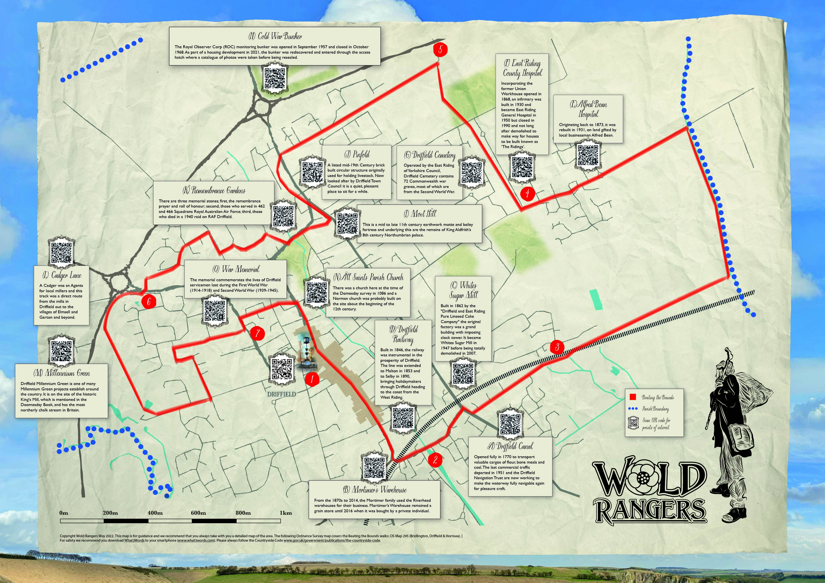
Beating the Bounds 1
Driffield Canal (A - Beating the Bounds 1)
The town's economy boomed when local businessman Thomas Porter orchestrated the extension of the region’s canal system to Driffield in 1770. The Driffield Canal opened after 5 years of construction having cost around £15,000. It was opened progressively, with the first section completed on 12 December 1768, the next section to Wansford opened by 25 May 1769, and the whole canal formally opened on 25 May 1770. The now tranquil and beautiful Riverhead area of the town became a hive of activity back then, with flour and bone meal mills, warehouses and granaries, malt houses and breweries, coal yards and manufacturing industries. The last commercial traffic departed in 1951 and the Driffield Navigation Trust was later formed with the aim of restoring the waterway to a navigable condition.
Mortimer and Mortimer’s Warehouse (B - Beating the Bounds 1)
‘Mortimer’ is a prominent name in Driffield. Resident John Robert Mortimer (1825-1911) is recognised for his contribution to modern British archaeology, publishing “Forty Years’ Researches in British and Saxon Burial Mounds of East Yorkshire” in 1905. He also founded James Mortimer Ltd., a grain and seed merchants, in 1869. From the 1870s to 2014, the Mortimer family used the Riverhead warehouses for their business. Mortimer’s Warehouse remained a grain store until 2016 when it was bought by a private individual.
Whites Sugar Mill (C - Beating the Bounds 1)
The remains of Whites Sugar Mill on Anderson Street, Driffield makes a sorry sight indeed. Built in 1862 by the "Driffield and East Riding Pure Linseed Cake Company" by 1887 the factory employed more than 100 people. The building caught fire that same year and the original clock tower was destroyed in a blaze which burned for three days. The Linseed Cake Company set about rebuilding the premises, incorporating a redesigned and slightly less imposing clock tower, it ceased trading in 1947 and the mill was bought by Whites, a Hull sugar firm. (need to add more info about Whites and when it closed etc.) A large part of the works was demolished in 2007 due to structural damage.
Driffield Railway (D - Beating the Bounds 1)
The railway has been instrumental in the prosperity of Driffield since it arrived here in October 1846. The original line was extended to Malton in 1853 and to Selby in 1890, a development which brought large numbers of holidaymakers through Driffield heading to the coast from the West Riding. The Yorkshire Wolds Railway charity is currently working to restore a short section of the Driffield to Malton line (known as the Malton Dodger) as the East Riding’s only heritage railway and is worth a visit just outside Driffield at Fimber Halt (near Wetwang).
Alfred Bean Hospital (E - Beating the Bounds 1)
The facility has its origins in the Driffield Cottage Hospital on Bridlington Road which was completed in 1873. When the cottage hospital became rather decrepit, a new facility, entirely funded by Alfred Bean, a local businessman, was commissioned and completed in 1931. It joined the National Health Service in 1948 and, after the East Riding General Hospital closed in 1990, the Alfred Bean Hospital became the main hospital serving Driffield and surrounding villages.
East Riding County Hospital (F - Beating the Bounds 1)
The facility had its origins in the Driffield Union Workhouse which was designed by John Edwin Oates and opened in 1868. An infirmary was established at the north end of the site and it became the Driffield Public Assistance Institution in 1930. During the Second World War, an emergency medical service hospital known as Driffield Base Hospital was built on the site. It joined the National Health Service as the East Riding County Hospital in 1948 and became the East Riding General Hospital in 1950 from when it expanded and took over many of the old workhouse buildings. Modern operating theatre facilities were built on the site in the 1960 but after local services transferred to the new Alfred Bean Hospital next door, the East Riding General Hospital closed in 1990. The buildings were demolished in 1992 and the site was sold for residential development now known as ‘The Ridings’.
Driffield Cemetery (G - Beating the Bounds 1)
The cemetery was administered by the Great Driffield Burial Board, formed in 1864, later by Great Driffield Urban District Council acting as the burial authority. Responsibility for the cemetery was transferred to East Yorkshire Borough Council in 1974 and then to East Riding of Yorkshire Council in 1996. Driffield Cemetery contains 72 Commonwealth war graves, of these, by far most are from the Second World War. The Chapels within the cemetery grounds were designed by Gilbert Scott Jnr.
Cold War Monitoring Bunker (H - Beating the Bounds 1)
The Royal Observer Corp (ROC) monitoring bunker (which extends some 5m underground) was constructed in the mid-1950s and together with a WWII overground Orlit B Observation Post they were decommissioned in 1968 (the overground observation post has since been demolished). The observation post was opened in September 1957 and closed in October 1968. As part of the housing development in 2021, the bunker was rediscovered and entered through the access hatch. Fifty-two digital photographs were taken recording the building and interior fittings including a bunk bed, desk and toilet.
Moot Hill (I - Beating the Bounds 1)
This is a mid to late 11th century earthwork motte and bailey fortress, founded by Morcar. Underlying the castle are the postulated remains of King Aldfrith’s 8th century Northumbrian palace and evidence of 4th century Roman occupation. After Morcar’s rebellion the castle was abandoned until the early to mid 13th century, when it was re-fortified as an important royal residence. Excavations in 1975, found several phases of bridge construction across the wide ditch that still separates the motte from its bailey. This once large motte has been badly damaged by 19th century quarrying and houses have encroached on the bailey. (A moot hill or mons placiti (statute hill) is a hill or mound historically used as an assembly or meeting place)
Pinfold (J - Pinfold)
This is a listed mid-19th Century brick built circular structure, approximately 13 metres in diameter, with entrance to south-west and originally used for holding livestock. Now looked after by Driffield Town Council it is a quiet, pleasant place to sit for a while.
Remembrance Gardens (K - Beating the Bounds 1)
This site features three memorial stones, one of granite and two of sandstone. Each stone bears a plaque detailing: first, the remembrance prayer and roll of honour; second, those who served in 462 and 466 Squadrons Royal Australian Air Force (A.A.A.F.) at Driffield and Leconfield; third, those who died in a 1940 raid on RAF Driffield. In addition, there is a memorial to those who lost their lives in the Lockington Rail crash which occurred on 26th July 1986.
Cadger Lane (L - Beating the Bounds 1)
A Cadger was an Agents for local millers and this track was a direct route from the mills in Driffield out to the villages of Elmswell and Garton and beyond. There is a reference to this from 1642 –‘ They call in the morninge, and if wee have anythinge for them they goe on to Garton and call for it againe as they come backe, Elmswell’. (www.yorkshiredictionary.york.ac.uk/words/cadger)
Millennium Green (M - Beating the Bounds 1)
Driffield Millennium Green is one of many Millennium Green projects establish around the country. It is on the site of the historic King's Mill, which is mentioned in the Doomesday Book, and has the most northerly chalk stream in Britain.
All Saints Parish Church (N - Beating the Bounds 1)
There was a church here at the time of the Domesday survey in 1086. Some large blocks of masonry are built into the inner wall of the tower ringing chamber and may have come from this Saxon building. A Norman church was probably built on the site about the beginning of the 12th century and the church received its present general pattern about 1170-1200. Between 1878 and 1880 an extensive restoration was carried out by George Gilbert Scott Jnr.
War Memorial (O - Beating the Bounds 1)
The memorial commemorates the lives of Driffield servicemen lost during the First World War (1914-1918) and Second World War (1939-1945)
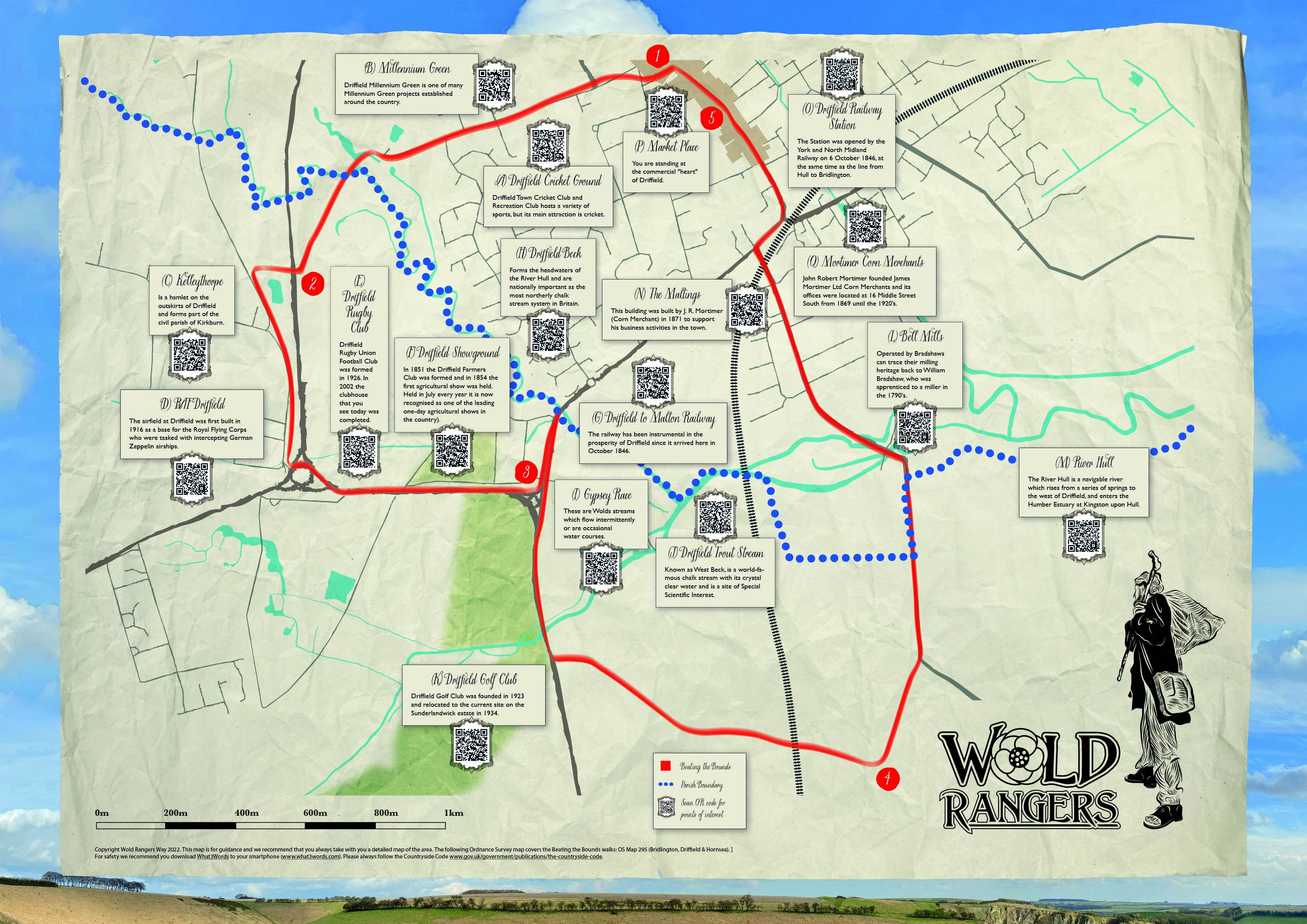
Beating the Bounds 2
Driffield Cricket Ground (A Beating the Bounds 2)
Driffield Town Cricket and Recreation Club hosts a variety of sports, but its main attraction is cricket, with the first team playing in the ECB Yorkshire Premier League North. The site covers eleven acres and provides a variety of sports for the local area, including two cricket pitches, two bowls greens, six grass tennis courts, three hard tennis courts and a two-lane fully enclosed ECB approved cricket practice facility. Driffield cricket club boasts a number of first-class cricketers including Andrew Gale, Richard Pyrah, Steven Patterson, Jonny Bairstow, Ishara Amerasinghe and Abid Ali who have all played for the club however, the most famous was John Thomas Brown (1869 – 1904) known as ‘JT’ or Jack Brown. Born in Driffield he became a professional cricketer and Yorkshire's first great opening batsman. Brown's form in 1894 was such to earn him a Test debut against Australia at Sydney in 1894/95 and he kept his place for all five Test matches. His innings of 140 in the final test of the 1894-5 series brought the Ashes back from Australia. He is still the only player to score two triple hundreds for Yorkshire.
Millennium Green (B - Beating the Bounds 2)
Driffield Millennium Green is one of many Millennium Green projects established around the country. It is on the site of the historic King's Mill, which is mentioned in the Doomesday Book, and has the most northerly chalk stream in Britain
Kellythorpe (C - Beating the Bounds 2)
RAF Driffield (D - Beating the Bounds 2)
The airfield at Driffield was first built in 1916 as a base for Royal Flying Corps who were tasked with intercepting German Zeppelin airships. The following year Eastburn (as it was then known) was selected to become a proper military air station. When the RAF began to expand in the 1930s, the old World War I aerodrome sites were first to be developed as permanent stations and in 1934 the site at Eastburn was no exception. In 1934 the construction of RAF Station Driffield began and was operational by 1936. Driffield became a Bomber Command airfield, initially occupied by 58 and 215 Squadron. Driffield became the victim of the first concentrated bombing when on 15 August 1940 a large formation of German bombers raided the airfield, scoring 171 direct hits, causing 14 deaths and the destruction of 12 Whitley bombers. Several other bombers, as well as buildings were damaged, and the airfield was put out of action for several days. In early 1941 Driffield was returned to operational use, but this time as a fighter station with squadrons of Hurricanes and Spitfires before it was reclaimed again by Bomber Command in the Spring. The entire reconstruction took a year and a half, so the airfield did not reopen until June 1944. 466 Sqn returned to the airfield and provided the core for a reformed 462 Sqn (also RAAF) from mid-summer. Both squadrons operated alongside each other until the end of 1944. 466 Sqn flew its last bombing raid two weeks before the end of the war, which was also the last raid from Driffield. In total the airfield had lost 87 aircraft due to enemy action or crashes in the UK: Whitleys, Wellingtons and Halifaxes. Post WW2, the station at Driffield continued to be used for various activities including Thor nuclear missiles in the 1960’s. In 1977, the RAF handed the airfield to the Army, who renamed it ‘Alamein Barracks’ and used it as a driver training centre. They used the airfield until they finished converting RAF Leconfield for use as a driving school. The runways were removed in the early 1980s, and the resulting hardcore was used in the construction of the Driffield bypass.
Driffield Rugby Club (E - Beating the Bounds 2)
Driffield Rugby Union Football Club was formed in 1926 and until the 1950s played its matches on a field off St Johns Road in Driffield. In these early years the clubhouse was based at the Keys Hotel where the players’ baths were in beer barrels sawn in half! Following WWII the club played at four different grounds before finally coming to an agreement with the Driffield Show Society to use their newly-acquired showground. The changing facilities were at the nearby aerodrome but in 1958/59 became unavailable so the old RAF Cinema and Chapel at Kelleythorpe were purchased and converted opening in April 1960. In the autumn of 1996 an application was made to Sport England for lottery funding to help build the new clubhouse you see today. Work got underway in the summer of 2001 and having cost over £1 million, the new clubhouse was ready for use by January 2002.
Driffield Showground (F - Beating the Bounds 2)
Driffield Showground - As farming began to improve in the 1830s, Farmers’ Clubs, mainly for discussion and consideration of all new methods that were being brought forward, began to be formed up and down the country, as the Victorians were much given to improving themselves.It was in 1851 that the Driffield Farmers’ Club was formed and they held experiments with the new agricultural machinery on Mr Hopper’s farm at Kelleythorpe in 1852.In 1853 the Farmers’ Club developed into the Driffield and East Riding Agricultural Society. In 1854 the first Driffield Show was held with an exhibition of farm stock, poultry, horses and implements in a field within a short distance of the town.
Driffield to Malton Railway (G - Beating the Bounds 2)
The railway has been instrumental in the prosperity of Driffield since it arrived here in October 1846. The original line was extended to Malton in 1853 and to Selby in 1890, a development which brought large numbers of holidaymakers through Driffield heading to the coast from the West Riding. The Yorkshire Wolds Railway charity is currently working to restore a short section of the Driffield to Malton line (known as the Malton Dodger) as the East Ridings only heritage railway and is worth a visit just outside Driffield at Fimber Halt (near Wetwang).
Driffield Beck (H - Beating the Bounds 2)
Forms the headwaters of the River Hull and are nationally important as the most northerly chalk stream system in Britain.
Gypsey Race (I - Beating the Bounds 2)
These are Wolds streams which flow intermittently or are occasional water courses and called the Gypsey Race (with a hard 'g'). The name derives from the word 'geyser'; which in turn comes from the Norse 'gypa' - a spring. The water comes from natural underground reservoirs and when the water rises to a particular level it is siphoned to the surface. Starting just west of the A614, The Gypsey Race goes under the Driffield Showground by way of a man-made culvert, before joining the main river at Hallimanwath Bridge. It is not the same stream as the one that rises further north at Wold Newton which is named slightly differently (Gypsie Race) which eventually flows into the sea at Bridlington Harbour. This is the most northerly winterbourne chalk stream in the East Riding and pre-history, it possibly linked to the River Hull system at Kilham but its course may have been later blocked by glacier action.
Driffield Trout Stream (J - Beating the Bounds 2)
Driffield Trout stream, known as West Beck, is a world-famous chalk stream with its crystal clear water and a site of Special Scientific Interest. For over 150 years fishing clubs such as Driffield Anglers and the West Beck Preservation Society have tended and conserved these waters and their famous trout. Many of the world’s most accomplished anglers have made the pilgrimage to Driffield area to fish for its famous trout. Brown trout are not confined to just the West Beck but are also present in the myriad of smaller chalk streams throughout the local area. Chalk Rivers are a unique and irreplaceable part of our heritage and the landscape of Britain.
Driffield Golf Club (K - Beating the Bounds 2)
Driffield Golf Club was founded in 1923, initially being sited on the east side of Driffield at Meadow Road. A move to the current site on the Sunderlandwick estate took place in 1934. The estate was owned by the late Sir Thomas Ferens and provided for an 18-hole, parkland course. During the Second World War the club gave up 9 holes for agriculture in support of the war effort. Thereafter it remained as a 9-hole course until the early 1980’s when an extension programme was under taken to return the course to its present 18 holes which was officially opened on the 2nd of September 1990. The Clubhouse (formerly a wooden structure) was replaced in 1980 and in 2001 underwent major extensions and refurbishment.
Bell Mills (L - Beating the Bounds 2)
Bell Mills operated by Bradshaws can trace their milling heritage back to William Bradshaw, who was apprenticed to a miller in the 1790's. William’s grandson, Eleazar settled in Driffield in 1875, to be Mill Manager for Richard Kirby, the owner of Bell Mills. He became a partner in the business in 1880 and upon Richard’s death in 1894 bought the business. In 1910 he bought the freehold to the mill from the Londesborough Estate. He was joined in business by three of his five sons (the other two choosing farming and baking as careers). The company was restructured as a Limited Company in 1927, trading as E B Bradshaw & Sons Limited, with brothers John, Peter and Alfred as directors. The business is now run by John and Alfred’s grandsons, who are 6th generation Bradshaw millers. In June 1949 a disastrous fire completely destroyed Bell Mills. However, literally out of the ashes’ John and Alfred Bradshaw built a completely modern mill and installed all the latest milling equipment that was available in the 1950's and was further modernised in 1970. By 1990, the directors decided to undergo a major remodelling, taking out all the machinery and replacing it with a new mill. “C” mill was commissioned in the Summer of 2018 and is one of the most technically advanced mills in Northern Europe.
River Hull (M - Beating the Bounds 2)
The River Hull is a navigable river which rises from a series of springs to the west of Driffield, and enters the Humber Estuary at Kingston upon Hull. The upper reaches became part of the Driffield Navigation from 1770. The upper tributaries are designated Sites of Special Scientific Interest (SSSI’s). The designation is made to protect this system of chalk streams as they are important for the many species of aquatic plants and animals indicative of the chalk habitat. The East Yorkshire Chalk Rivers Trust works with the Environment Agency on restoration projects to protect this chalk river system. The upper river is important for its brown trout and grayling. Fish species on the lower river include bream, pike, roach, dace, chub lampreys and eels. Numbers of mammals including the otter and water vole are at a healthy level throughout the catchment.
The Maltings (N - Beating the Bounds 2)
This building was built by J. R. Mortimer (Corn Merchant) in 1871 to support his business activities in the town with a private railway siding linking it to the Hull to Bridlington Railway line. (For more information about J. R. Mortimer and his life in Driffield as a merchant and leading British Archaeologist why not walk our ‘Mortimer Trail’ around the Town.
Driffield Railway Station (O - Beating the Bounds 2)
The Station was opened by the York and North Midland Railway on 6 October 1846, at the same time as the line from Hull to Bridlington. The independent Malton ! Driffield Railway Company obtained parliamentary approval to build a branch line between it and Malton in the same year. There were five signal boxes regulating the passage of the trains through Driffield - Wansford Road, Eastgate or Depot crossing, Station, Skerne Road and Driffield West on Beverley Road. All allowed vehicles and pedestrians across as the footbridge on Eastgate South had not been built. At some of the crossings such as on Wansford Road and Eastgate, signalmen lived in the railway houses adjacent which can still be seen today. At one time approximately 50 people were employed at Driffield Station as the operation of the railway was divided into passenger and goods departments, each with its own foreman and clerical staff, under the overall control of the stationmaster who lived in his house on the platform of the station itself.
Market Place (P - Beating the Bounds 2)
Market Place - You are standing at the commercial "heart" of Driffield where the founder of Methodism, John Wesley, preached in 1772 from the balcony of the 18th century Bell Hotel and the General Election results for the Buckrose constituency used to be announced from here.
Mortimer Corn Merchants (Q - Beating the Bounds 2)
John Robert Mortimer was born in Fimber on 15 June 1825 and founded James Mortimer Ltd from the family farm in Fimber in 1869. James Mortimer Ltd’s offices were located at 16 Middle Street South from 1869 until the 1920’s, when they purchased the house adjacent to their warehouse facilities at Riverhead. Riverhead Warehouses, situated alongside the Driffield Navigation basin were first rented by Mortimers in the early 1870’s and subsequently purchased. Over the following years, J R Mortimer’s relatives became involved and took over the business. The company has steadily grown and in 2013, acquired a 2.25 acre site on the Kelleythorpe Industrial Estate.
Discover our Trods named after Ginger Joe, Horse Hair Jack, Dog Geordie, Mad Halifax, and Croom Mabel for shorter circular routes.
The Wold Rangers Way (44 mile) The full 44 mile circular trail through the ancient green lanes and bridlepaths of the spectacular Yorkshire Wolds...
Croom Mabel Trod (3 miles) Croom Mabel, clothes piled on her pram, drooping cigarette, dog by her side, adorned in a gold lame evening dress...
Horsehair Jack Trod (9 miles) Horsehair Jack, sly, dishonest, no stable lads horsehair was safe, timing his offences for a winter break in jail...
Ginger Joe Trod (13 miles) Ginger Joe, flaming beard, piecing blue eyes, bundle, billy can and dog; a philosopher who greeted the King and Queen...
Dog Geordie (17 miles) Dog Geordie, the last Wold Ranger, his dog and ferret by his side telling his tales of Rangers long gone...
Mad Halifax (22 miles) Mad Halifax, a giant, striking terror; wild hair, ginger beard and a cunning nose for the delicious smell of baking...
© 2021 Driffield Town Council, 2-4 Market Walk, Driffield, East Yorkshire YO25 6BW • Telephone: 01377 254160 • Email: townclerk@driffieldtowncouncil.gov.uk • Privacy Policy
Registered Charity number: 1193343
Website by EVERYTHING | BUT THE PRODUCT LTD
Professional design solutions for small businesses

 facebook.com/woldrangersway
 twitter.com/rangerswold